 |
erosion on the pinnacle |
|
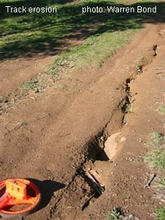
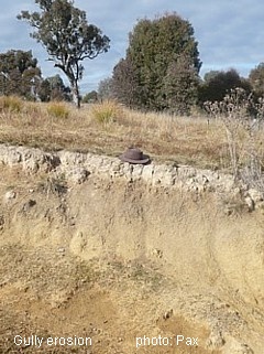
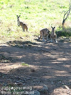
After weed infestation, the next most noticeable sign of degradation on The Pinnacle Nature Reserve is erosion. Land Resource surveys carried out in the 1990s identified the soils that cover most of the Reserve as having a moderate to very high erosion hazard, with patches, mainly in low lying areas, having extreme erosion hazard; large areas were observed to have moderate sheet erosion and minor to moderate gully erosion was also present Since fotpin observations of the area began in 2009, it has been observed that there is significant erosion along tracks and paths, some gully erosion, and erosion adjacent to shaded areas used by kangaroos. The latter have continued and are perhaps more obvious after the drought.
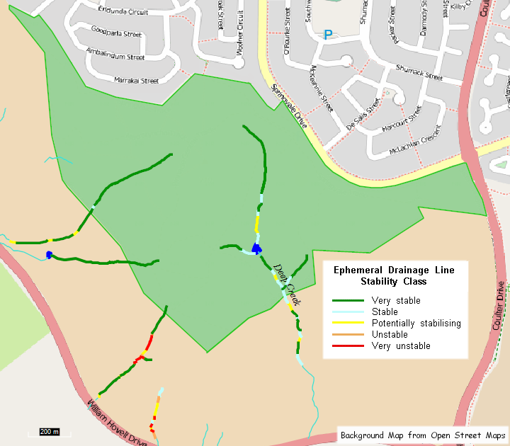
We consider controlling and reversing the impacts of these landscape scale threats to be critical to securing longer term investments in ecological restoration, resilience and connectivity outcomes for the Reserve. fotpin members are currently surveying and assessing soil condition and erosion across the Reserve, the Bottom Pinnacle and the North Kama property (see location map), a total area of approximately 275 ha. We are using the CSIRO’s Landscape Function Analysis (LFA) methodology, developed by fotpin member David Tongway, to assess track, ephemeral drainage line (waterway) and soil surface condition. We will also record and assess erosion problems caused by unauthorised BMX tracks constructed in the Reserve. The surveys will provide a baseline condition for fotpin’s long-term land and water monitoring program, as well as identify tracks, drainage lines and grassy areas at risk of erosion or needing early intervention. The first erosion control works based on the outcomes of the survey were commenced in April 2012 and will continue as materials become available. The LFA methodology is a repeatable monitoring procedure that assesses how well a landscape is working as a biophysical unit. LFA uses rapidly assessed indicators of the status of processes occurring close to the soil surface. The indicators may be biological, such as perennial vegetation or cryptograms, or abiotic, such as engineering structures. Track assessments classify track segments according to the nature of any erosion (e.g. rilling), the accumulation of alluvium, or the presence of a stony surface. The ephemeral drainage line (EDL) assessment considers a range of factors including slope, slope surface, drainage line wall and floor vegetation, profile, and wall and floor erodibility, and generates a risk score. An example of the output from the EDL assessments is shown below. It is planned to extend the EDL assessments to the Kama Nature Reserve (see map) to follow at least some of the drainage lines to the Molonglo River. Soil surface assessments consider rainsplash protection, perennial vegetation cover, litter, cryptograms (soil surface plant communities), crust brokenness, soil erosion severity, deposition of materials, surface nature and roughness, and soil solubility and texture. For example, “Criterion 7: Deposited Materials” has four classes to assess the nature and amount of alluvium transported to and deposited on the “query zone”. SSA scores are entered into an Excel spreadsheet and relative values for soil stability, infiltration and nutrient cycling are produced. Representative soil surface transects will be chosen on the basis of the available erosion hazard mapping from the 1990s Land Resource surveys, as well as evidence of disturbance. We will survey as many soil surface transects as possible given the resources available as well as assess some 15 km of tracks and 5 km of drainage lines. Work on the ephemeral drainage line assessments has been completed, but completion of the track and soil surface assessments is on hold because of more pressing requirements for volunteers' time controlling weeds. Further Information Restoring Disturbed Landscapes: Putting Principles into Practice, by David Tongway and John Ludwig. Island Press. 2011.
Preliminary Output from Ephemeral Drainage Line Assessment
|
© Friends of The Pinnacle