

Suggested Walks on The Pinnacle Nature Reserve
Pinnacle Main Loop
Starting point: end of Dungowan St, Hawker
Distance: 5.0 km return
Time: Allow 2 hours
Difficulty: Moderate
 Grade 3 |
Total ascent/descent: 130 m |
Description: A long loop around most of the reserve’s boundary. A favourite with trail runners or walkers looking for a longer walk in nature with pleasant views. This walk runs down the reserve’s western boundary before looping back up to join the management trails around the top boundary of the reserve. As you head along the western boundary, there are spectacular views of the Molonglo Valley and Brindabellas out to your right.
Directions
The walk starts at the boom gate at the end of Dungowan St,
just to the right of the sign describing the walks.

|
|
| 1. |
Walk through the gap on either side of the boom gate and down the track for 50 m until you reach the "famous" Dungowan St tree - a big old hybrid Yellow Box (Eucalyptus melliodiora) that is used for nesting by several bird species in spring. Turn left after the tree and step through the gate or the horse crossing (cavaletti) at the left of the gate. 
|
| 2. | You are now on the Dowling Track which runs alongside the western boundary of the reserve. 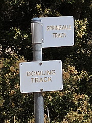
Follow it until after 100 m you reach a fork in the track and the sign post shown in the photo. While unfortunately misleading (because the sign for the Springvale Track is pointing in the wrong direction) it is useful for confirming that this is the point at which you take the right-hand track to stay on the Dowling Track running alongside the boundary fence. |
| 3. |
As you walk the 400 m to the next track junction you can contrast the open forest of Red stringybark (Eucalyptus macrorhyncha) on the left with the unleased government land on the right. Aerial photographs show that this remnant patch of Eucalyptus macrorhyncha has been present since at least 1940 and we suspect for some considerable time before that. At the track junction (pictured) don't turn left up the Macrorhyncha Track but continue
straight ahead on the Dowling Track for another 800 m, keeping the fence on your right.
|
| 4. |
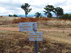
Just before you come to the next track intersection the track is cut heavily into the slope and is further from the fence. This cutting and alignment of the track is a consequence of the track following the route of a pipeline which runs underneath the track and conducts water to western Hawker from the Weetangera tanks. You may have noticed Icon Water's markers and inspection points for the pipeline along the edge of the track. Just after the end of the cutting you reach an interpretive sign and a track leading down to the right and through a gate into the Kama Link paddock. This is the turn-off for the Kama Link walk. To continue on the Pinnacle Main Loop, keep going past this sign to the sign post at
the next intersection where the Central Track comes in from the left, the Dowling Track ends
and the Tully Boundary Track begins (the latter wrongly posted on the sign as the "Tully Boundary Trail").
|
| 5. |
Continue straight on through the intersection on the Tully Boundary Track. 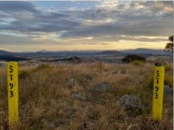
From the highest point a 60 m long foot track on the right leads to a lovely viewing spot (pictured) with views over Southern Canberra towards the mountains beyond. |
| 6. | Returning to the Tully Boundary Track, turn right and walk 375 m down a steep section past the intersection with the Valley Track on the left and soon after to the point where Deep Creek exits the Reserve, the lowest point on the walk. |
| 7. |
From the creek, the track climbs slowly at first and then more steeply as you round a sweeping left-hand bend. 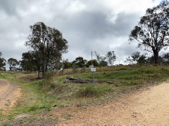
Soon after you will arrive at an intersection (pictured) where the Tully Boundary Track makes a sharp right turn and continues to the East. Instead of following that, continue up the hill bending slightly left on the ACTEW Pump Track. The woodland to your left, as the track bends around to the right and then again to the left, is rich in native species including many wildflowers in spring and a number of magnificent mature eucalypts more than 100 years old. |
| 8. |
The mobile phone tower will now have come into view as the track meanders its way in that direction. At the phone tower, turn left onto the Springvale Track. Continue straight through the intersection 10 m later and climb the mound with the water supply tanks on the left. There are nice views of the reserve from the top of the mound, which was formed by pushing up the spoil removed to make a level platform for the tanks to partially screen the tanks from Springvale Drive. |
| 9. |
Descending from the mound you will encounter another intersection and again continue straight through it. After another 20 m you'll come to a fork in the track. The left hand fork leads to a gate (with pedestrian access on the right hand side) and marks the commencement of the Central Track. 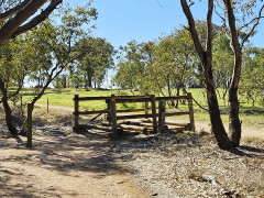
The right hand fork leads to a cavaletti (fence crossing for horses, pictured) and is the continuation of the Springvale Track. You may choose either fork as both tracks lead, after 100 m, to the same point. |
| 10. |
The Central Track and Springvale Tracks come together again at The Pinnacle Noticeboard. Pause to see what's on display at the moment then continue on the Springvale Track (outside the fence but still in the reserve). |
| 11. |
As you walk along the Springvale Track the woodland to the left for the first 600 m is predominantly the result of tree planting. For the first 300 m of the track the area to the left was planted by the Pinnacle Environment Group in 1991 while for for the following 300 m trees were planted in 1984 under the Government's Commonwealth Employment Program. The understorey of native shrubs, grasses and wildfowers is slowly making a comeback. The track then bends to the right. The woodland on the left for the next 250 m has regenerated naturally from remnant woodland. It is significant that the bend in the track marks a boundary between different landholders in the period between 1915 and the resumption of leases for the establishment of Hawker and Weetangera in the 1960s. |
| 12. |
 As you approach the intersection with a foot track (pictured) leading into the reserve from the
western end of Marakai Street you will notice the density of trees increasing as the vegetation
transitions from box gum woodland to an open stringybark forest (Eucalyptus Macrorhyncha).
This continues most of the way to the end of the walk, although there is unfortunately some
encroachment into the edge of the forest by non-native and non-local native plants from the nearby
suburban gardens.
As you approach the intersection with a foot track (pictured) leading into the reserve from the
western end of Marakai Street you will notice the density of trees increasing as the vegetation
transitions from box gum woodland to an open stringybark forest (Eucalyptus Macrorhyncha).
This continues most of the way to the end of the walk, although there is unfortunately some
encroachment into the edge of the forest by non-native and non-local native plants from the nearby
suburban gardens. |
| 13. | About 100 m past the track from Marakai Street the track bends sharply to the left and begins a steep descent back down to Dungowan St. The small area to the right as you negotiate the bend has quite a few native shrubs and wildflowers that may be in flower if you're there at the right time. |
| 14. | Where the track levels out you have the choice of returning to Dungowan Street on a foot track along the back of the houses or continuing to follow the management trail until you reach the intersection you left at step 2 of these directions and retracing your steps back to your starting point from there. |
