 
|
progress in blackberry control |
|
Progress in controlling Blackberries Measurements and analysis by Warren Bond (updated July 2026)
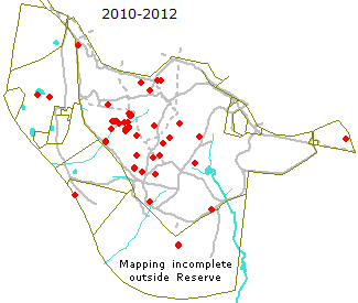
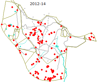
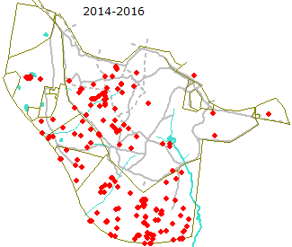
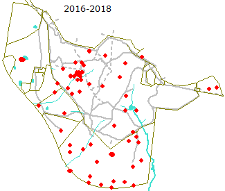
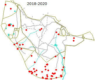
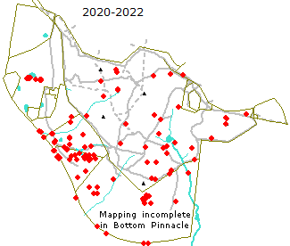
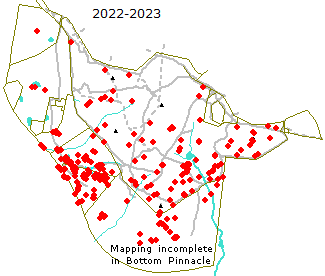
Summary Persistent mapping, treatment and follow-up of occurrences of blackberry (Rubus anglocandicans) resulted in their virtual elimination from the Reserve and contraction of their prevalence towards the William Hovell Drive boundary of the controlled area up to 2020. Unfortunately the favourable growing conditions between 2020 and 2023 saw a resurgence in numbers, especially in the 2022-23 season. A significant increase was seen across the Reserve and was particularly noticeable in the Kama Link paddock* (the 2016 Offset addition to the Reserve). This is likely associated with the proximity of that area to William Hovell Drive where blackberries are rampant along the verge and untreated by City Services until autumn 2023, thus providing a rich source of re-infestation. The verge adjacent to Kama Link is now regularly sprayed by fotpin. There has been a significant improvement in blackberry numbers on the core Reserve since 2023 but they are still considerably higher than in 2018-20. Elevated numbers remain in Kama Link paddock and along the part of Southern paddock closest to Bottom Pinnacle where, apart from control by fotpin within a 100 m buffer strip inside Bottom Pinnacle, blackberries remain largely uncontrolled. *See paddock map for location of Kama Link and other paddocks. Background and methodology Friends of The Pinnacle commenced recording the locations of blackberry bushes and spraying them with the recommended rate of Brushoff® (Metsulfuron methyl) at the end of 2010. Although some unrecorded grubbing continued for a year or two we have a fairly good record of their occurrence and treatment. Initially only carried out on the Reserve, in 2012 this was practice was extended to the neighbouring paddocks of North Kama and Bottom Pinnacle with the aim of reducing the sources from which birds could bring seeds to the Reserve. The locations of blackberry bushes are recorded on handheld gps whenever they are encountered by members carrying out weed control of other activities. These locations loaded into a file and are visited twice a year(spring and autumn) for spraying. Each location is kept on file and revisited twice a year until there has been no sign of regrowth or new plants in that location for two years. Change in prevalence over time The maps below show the locations of all blackberries treated or retreated. They have been grouped in 2-year periods.
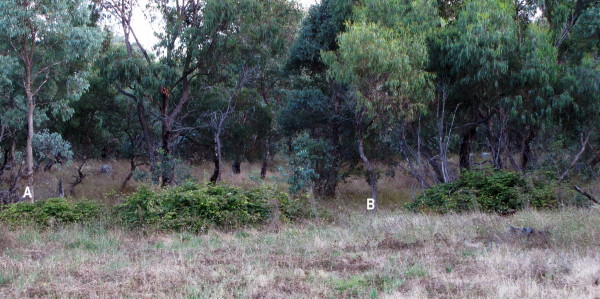
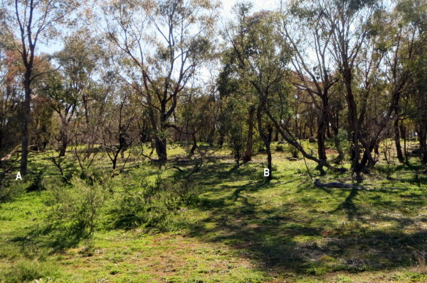
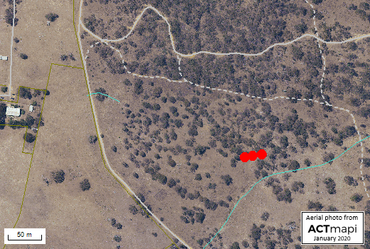
The number of plants treated increased through the period 2010 to 2016, primarily because the intensity of our coverage of the whole area increased. From 2016 to 2020 however numbers reduced with the largest densities being in areas neighbouring the William Hovell Drive boundary (furthest from the "core" Reserve). This suggests that our plan to reduce their number on the Reserve by controlling them as far as possible in the neighbouring paddocks may have been successful. The period since 2020 has seen a resurgence of numbers across the Reserve, particularly in the Kama Link paddock (the 2016 Environmental Offset added to the Reserve) and the Southern paddock. As previously noted, the higher density in the Kama Link paddock is likely connected to the proximity of that area to William Hovell Drive where blackberries are rampant along the verge (and beyond) and largely untreated (until autumn 2023), thus providing a rich source of re-infestation. Similarly Southern paddock borders onto Bottom Pinnacle where after 2020 we were no longer able to continue blackberry control (see note below), resulting in a larger resurgence (unmeasured) in numbers there, again in response to the lack of control along William Hovell Drive. Regular spraying has been done by fotpin along the verge where it borders on the Kama Link paddock since 2022. A significant reduction can be seen between the 2022-24 and 2024-26 maps on the reserve except in Kama Link paddock and the southern edge of Southern paddock, but new hotspots are still occurring. Numbers are still elevated compared with 2018-2020, especially in Kama Link. In Kama Link and the southern edge of Southern paddock numbers increased between 2022-24 and 2024-26. Note: After 2020, lack of resources unfortunately prevented systematic mapping and treatment of blackberries outside the Reserve in all but a 100 m buffer strip along the Reserve boundary (slightly bigger in the northwest corner of Bottom Pinnacle). Illustration of successful control by repeated spraying The largest blackberry patch on the Reserve since 2009 was the first to be sprayed. A collection of 3 separate bushes, its location is shown below. It was first sprayed at the end of December 2010. Follow-up checks have been carried out each autumn and spring as described above, and spraying of regrowth and (mainly) new plants and seedlings was required until November 2017. Since that time the area of the original patch has been free of blackberries. The photos below show the patch shortly after the first spraying and again in winter 2020. Two distinctive trees, labelled A and B, allow the photos to be compared despite the changes in vegetation, shooting angle and light conditions. The bushes visible in the left-hand foreground in 2020 are small acacias.
Location of largest blackberry patch on the Reserve in 2010
|



© Friends of The Pinnacle